My work was recently featured on the 'NASA Earth Observatory' website! A recent eruption of Nishinoshima, Japan, was imaged by the Landsat sensor, and my work with the ASTER sensor was talked about. To read the article, the link can be found below:
https://earthobservatory.nasa.gov/images/150489/nishinoshima-clears-its-throat
https://earthobservatory.nasa.gov/images/150489/nishinoshima-clears-its-throat
What Am I Interested In?
Collecting information on the products of volcanic eruptions, particularly the composition, mass and particle size of this material is essential to help us characterize the eruption style and probable processes leading to an eruption. However, this is a complex task, made difficult by the dangerous nature of collecting field samples. This is how my research career began – attempting to collect essential information on the products of volcanic eruptions while limiting the risks. I currently have three primary research foci that are all intertwined by the overall question of “Can we determine the properties of volcanic ash using remote thermal infrared image data and what does this tell us about the state of a volcano?”. To achieve this, I have applied established techniques in laboratory FTIR spectroscopy and image analysis in a unique way to answer this fundamental question.
If you're a Pitt Undergraduate student interested in our research, whether it be informal or for the GEOL 1901 Independent Study in GIS program, please feel free to drop me an email! I'm always excited to involve students in research, or collaborate if you have an idea in remote sensing or GIS you want to come and talk to me about.
Infrared Spectroscopy of Volcanic Material
 Hyperspectral and AVAL resolution volcanic ash spectra (from Williams and Ramsey, 2019)
Infrared spectroscopy is a technique that uses the amount of infrared (IR) energy that is reflected, transmitted or emitted from a sample to determine what it is made of. The chemical structure of the material (i.e. what elements are present and in what molecular arrangement) determine this property. I use it is as an analysis technique with volcanic products because a) it is non-destructive, and b) the data can be applied to remote sensing observations so we can determine what something is made from.
For my research, I am interested in analysis of volcanic ash or tephra. This is fine grained material, that is those particles < 2 mm in size. I measure the emissivity of these samples to determine their composition. I am in the process of building a spectral library of volcanic ash types that represent different eruption lithologies and eruption styles. The IR spectrum is sensitive to slight changes in composition, so I can use these data to determine the composition of each ash sample and try to understand the conditions under which it formed. I also try and take samples from the same volcano over time to see if the composition of the ash changes as the style of eruption seen does. In addition to this, I am also interested in the role of volcanic glass on the emission spectrum. Glass composition can either mirror or be very different to that of the bulk magma, which gives us information on the vent processes occurring.
For my research, I am interested in analysis of volcanic ash or tephra. This is fine grained material, that is those particles < 2 mm in size. I measure the emissivity of these samples to determine their composition. I am in the process of building a spectral library of volcanic ash types that represent different eruption lithologies and eruption styles. The IR spectrum is sensitive to slight changes in composition, so I can use these data to determine the composition of each ash sample and try to understand the conditions under which it formed. I also try and take samples from the same volcano over time to see if the composition of the ash changes as the style of eruption seen does. In addition to this, I am also interested in the role of volcanic glass on the emission spectrum. Glass composition can either mirror or be very different to that of the bulk magma, which gives us information on the vent processes occurring.
Image Analysis of Explosive Volcanic Eruptions
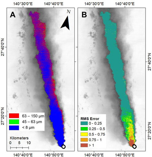 Particle size maps of a volcanic ash plume from Nishinoshima, Japan. An andesite ash end-member was used for this analysis. Panel A shows the particle size distribution derived from the spectral unmixing model, with panel B showing the RMS error for the retrieval (from Williams and Ramsey, 2022).
There is an increasing amount of data being collected on volcanic eruptions by satellite sensors. Many techniques already exist for extracting information on the quantity of SO2 and ash that is erupted from a volcano, monitoring the appearance and temperature of thermal anomalies, and monitoring fluctuations in flank deformation. However, determining the composition and particle size of the lithic, mineral and glass fragments that are erupted is not studied in detail via these techniques. However, it may be possible to do this if you treat the plume top like the surface of the Earth - that it is a solid surface, and emits energy in the same fashion. This will only work for that section which is opaque to upwelling ground radiance however, and to see this region in detail, you will need a dataset with a much higher spatial resolution. Therefore, I have applied a linear unmixing model to satellite image data collected by the Advanced Spaceborne Thermal Emission and Reflection Radiometer (ASTER) sensor to obtain this information. In order to use an unmixing algorithm, you need a spectral library as an input that has the same spectral resolution as the sensor. To do this, I have taken the ash spectra, and resolved them to ASTER's TIR spectral resolution. These methods have so far proven successful, and is starting to reveal some interesting information on the composition of these plumes, and the structure of the plume top. This is a major research investigation that I intend to continue in the future. Currently I am attempting to apply different unmixing models to better constrain the composition of these ash plumes, as well as using an ever expanding spectral library to derive this information.
Developing Novel Camera Technologies
Thermal cameras have opened up volcanoes to in-depth studies of temperature fluctuations that can inform us of the migration of magma beneath the surface. Furthermore, they can be used to provide information on a geologic surface through the use of techniques such as apparent thermal inertia. However, these cameras are broadband (i.e. they collect all information contained within a certain wavelength range), which limits their use to these applications. However, it may be possible to retrofit these sensors with filters, that can filter out all energy except the desired region of infrared light. I have been developing this apparatus at the University of Pittsburgh, in order to create a multispectral thermal sensor. We have siz filters which have band passes similar to the ASTER and MODIS sensor TIR channels. These rotate in a wheel mechanism in front of the thermal camera lens, with the camera collecting high speed (60 Hz) data. We have successfully obtained 6 band image data from this camera, and this data will soon be calibrated thanks to the efforts of our team. The hope is that we can observe volcanic processes using this camera, as well as use it to map other geologic features in multispectral detail. This will lend this data well to being analyzed using spectroscopic methods to extract mineralogy and particle size.
